The Nature Conservancy, Virginia's Eastern Shore (click here for project website)
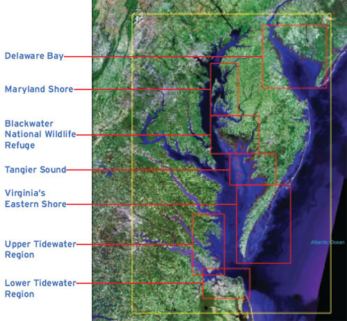
Application of the Sea-Level Affecting Marshes Model for Enhancing Coastal Resilience on Virginia’s Eastern Shore
Part of a project titled: “Enhancing Coastal Resilience on Virginia’s Eastern Shore” funded by the National Fish and Wildlife Foundation and carried out by The Nature Conservancy in partnership with the Accomack-Northampton Planning District Commission, the Virginia Coast Reserve Long-Term Ecological Research site, NASA, and the Chincoteague National Wildlife Refuge. The goal of the project is to enhance coastal resilience in the Eastern Shore of Virginia (Accomack and Northampton counties on the Delmarva Peninsula) by providing the scientific framework, decision-making support tools, and examples of real world, naturebased solutions needed to avoid costly, ineffective, management decisions that could have unintended consequences for this unique stretch of coast.
Northeast Regional Oceans Council (click here for project website)
Advancing Existing Assessment of Connecticut Marshes’ Response to SLR
In 2013 and 2014, the New England Interstate Water Pollution Control Commission (NEIWPCC) and the state of Connecticut funded a marsh-habitat migration study for the entirety of coastal Connecticut. The goal of the project was to use the Sea Level Affecting Marshes Model (SLAMM) to identify potential responses of Connecticut’s coastal marshes and adjacent upland areas to anticipated increases in mean-tide water level elevations in Long Island Sound (LIS) and Connecticut’s estuarine embayments.
Gulf Coast Prairie Land Conservation Cooperative (click here for project website)
Seamless application of SLAMM to the US Gulf of Mexico Coast (2014)
To support a focal species analysis, SLAMM was run for the entire US Gulf Coast
Mechanistic accretion feedbacks were derived based on the Marsh Equilibrium Model of Dr. James Morris
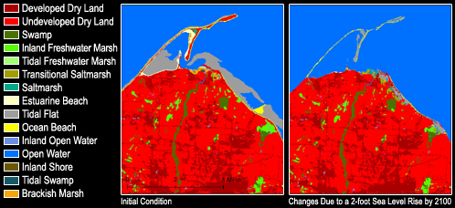
Creates a Gulf-wide database of SLAMM results (initial condition shown in the figure below) with a maximum call resolution of 30m x 30m
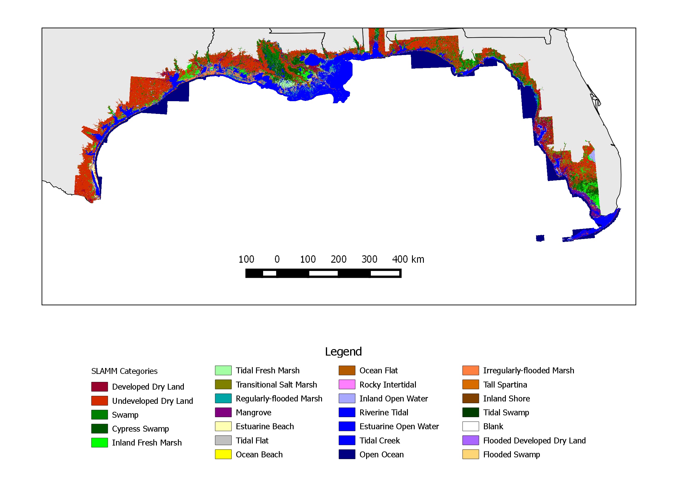
Intial wetland coverage conditions for the seamless application of SLAMM to the Gulf of Mexico funded by the Gulf Coast Prairie Land Conservation Cooperative
New England Interstate Water Pollution Control Commission (click here for project website)
Application of SLAMM to the coast of Connecticut and Westchester County, NY (2013-2014)
Used hydroflattened and hydroenforced LiDAR for improved hydroconnectivity modeling
Applied mechanistic accretion feedbacks based on the Marsh Equilibrium Model
SLAMM uncertainty module was used to create likelihood maps for improved decision making (see below)
Along with the NYSERDA-funded project described below, this project creates a seamless application of SLAMM to the Long Island Sound at a 5m cell resolution
New York State Energy Research and Development Authority (NYSERDA) (click here for project website)
Application of SLAMM to the coast of New York State (2013-2014)
Study are includes the Hudson River up to the Tappan Zee Bridge
Used hydroflattened and hydroenforced LiDAR for improved hydroconnectivity modeling
Applied mechanistic accretion feedbacks based on the Marsh Equilibrium Model
The SLAMM uncertainty module was used to create likelihood maps for improved decision making. For example, the uncertainty analysis provides maps which provide the percent liklihood that the habitat will change by a given time step (The map shown below presents the percentage liklihood of habitat change by 2100). In addition to habitat change, liklihood that an area becomes coastal wetland, flooded developed land, or open water were also mapped for this study.
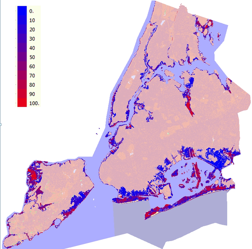
Percentage Liklihood of habitat change by 2100 for the New York City area.Study funded by the New York State Energy Research and Development Authority
Gulf of Mexico Alliance Habitat Conservation and Restoration Team (click here for project website)
Simulation of Southeast Louisiana with updated levee database (2013)
Using the National Wildlife Federation application of SLAMM to Southern Louisana as a base, the levee data were fully researched and a new input data layer derived. Simulations were then re-run. The report is available here.
United States Geological Survey
Submerged Aquatic Vegetation (2010 - 2013)
Development and integration of the capability to model submerged aquatic vegetation to SLAMM
Ducks Unlimited
Pacific Northwest (2007-2013)
Refinement of Puget Sound Analyses given new LiDAR data
Simulation of the entire coast of Oregon
Significant additions to SLAMM capabilities, including uncertainty and sensitivity modules
Development of the stand-alone SLAMM Uncertainty Viewer
US Fish and Wildlife Service (click here for all model-application reports)
National Wildlife Refuge simulations (2007- 2013)
In an effort to address the potential effects of sea level rise on United States national wildlife refuges, the U. S. Fish and Wildlife Service contracted the application of the SLAMM model for most Region 5 refuges. This analysis is designed to assist in the production of comprehensive conservation plans (CCPs) for each refuge along with other long-term management plans. 130 refuges have been completed to date in USFWS Regions 1,2,4,5, and 8
National Wildlife Federation
Large-Scale Analysis of Southern Louisiana (2009-2011)
SLAMM 6.0 model was applied to Southeast Louisiana, including a hindcast for model calibration and mechanistic accretion models
Glick, P., Clough, J., Polaczyk, A., Couvillion, B, and B. Nunley. 2011. Potential Effects of Sea-Level Rise on Coastal Wetlands in Southeastern Louisiana. Journal of Coastal Research 63(sp1):211-233
Chesapeake Bay, MD. 2007-2008
The SLAMM 5.0 model was applied to the entire Chesapeake Bay region and Delaware bay, a study area comprising slightly over seven million hectares (yellow rectangle below). The full technical report may be downloaded from NWF's Chesapeake web-page. GIS Raster files with results are available upon request.
Puget Sound (2007)
The SLAMM 5.0 model was applied to ten sites within Puget Sound, Washington, comprising over 600,000 hectares. The model was also applied to the mouth of the Columbia River including Willapa Bay, Astoria, and Tillamook. The modeled study area for this site alone was approximately 800,000 hectares. A model application report (11MB, MSWord format) is available for this as well as the final report. NWF project website.
Florida (2006)
The SLAMM 4.1 model was applied to nine sites within Florida, comprising over 1.7 million hectares. Funding for this model application was provided by the National Wildlife Federation. A model application report (MSWord format) is available for this as well as the final report titled An Unfavorable Tide.
Alaska
SLAMM Analysis of Kenai Peninsula and Anchorage, AK, Final Report
Assessing the Vulnerability of Alaska's Coastal Habitats to Accelerating Sea-level Rise Using the SLAMM Model: A Case Study for Cook Inlet
A White Paper on Date Requirements and Date Inventory for Alaska SLAMM Analyses
Gulf of Mexico Alliance - Funded by the Gulf of Mexico Foundation
Simulations and parameter sensitivty analyses for six refuges on the Gulf Coast:
Great White Heron NWR, FL
Ten Thousand Islands NWR, FL
Lower Suawnnee, FL
MS Sandhill Crane NWR, MS
San Bernard and Big Boggy NWRs, TX
The Nature Conservancy
Port Susan Bay WA & SLAMM 6 Production (2008-2009)
Refinement of accretion model to be spatially and temporally variable and subject to feedbacks from increased inundation.
Run of Port Susan Bay at five-meter scale given multiple management scenarios
Gulf of Mexico Simulations (2008-2011)
Saint Andrew and Choctawhatchee Bays, FL
Grand Bay NERR/NWR, MS
Jefferson County, TX
Galveston Bay, TX
Indiana University
EPA STAR Grant Entire Coast of Georgia and South Carolina: 2006-2008
GIS in conjunction with the SLAMM model has been used to predict changes in marsh area resulting from submergence and habitat conversion. Overlay of ecosystem-level measurements are used to predict how cumulative delivery of ecosystem services in each estuary will be altered in response to incremental (10 cm) increases in sea level. SLAMM has also been used to predict changes in shoreline protection potential of tidal marshes, commercial shrimp yields and the effects of dikes on delivery of ecosystem services. The results of the model will be scaled to the South Atlantic Coast (GA, SC) region. Official project web page.
Within this project, SLAMM 5.0 was created and salinity effects have been added to the SLAMM framework.
Results of this modeling effort may be viewed in SLAMM-VIEW.
|